i was doing a search for cities and highways that'd be primary hubs during a State/National of Emergency to no avail. Anyone have a link for such info? on account I'm wondering if my little corner of Texas is a part of it or not.when it comes to the hwy's passing through it..
You are using an out of date browser. It may not display this or other websites correctly.
You should upgrade or use an alternative browser.
You should upgrade or use an alternative browser.
State/National of Emergency
- Thread starter jimLE
- Start date

Help Support Homesteading & Country Living Forum:
This site may earn a commission from merchant affiliate
links, including eBay, Amazon, and others.
Jim, I think that completely depends on the nature of the emergency. Flood? EMP? Tornadoes? Riots? Invasion? Disease outbreak? Zombies? Trump winning 2020? And winning again in 2024?
An obvious starting point is military bases. Large cities, or around them. Step 1 is always containment.
An obvious starting point is military bases. Large cities, or around them. Step 1 is always containment.
- Joined
- Sep 7, 2013
- Messages
- 18,689
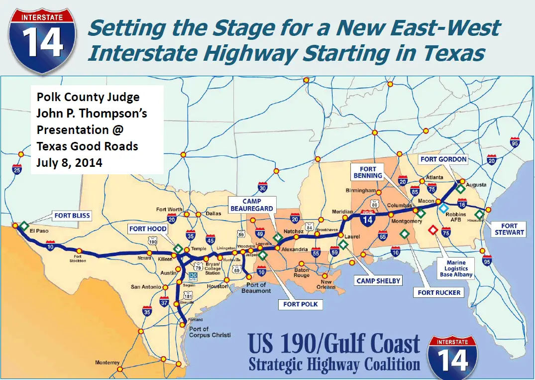
If they ever finish it, the I-14 Strategic Highway will be. There is already a stretch in Texas, and there is a Congressional caucus is being created by Texas, Mississippi and Louisiana to promote it. We desperately need it in Georgia and Alabama. If it's ever completed it will connect Goodfellow AFB, Fort Hood, Fort Polk, Camp Beauregard, Camp Shelby, Maxwell AFB, Fort Benning, Robins AFB, and Fort Gordon.i was doing a search for cities and highways that'd be primary hubs during a State/National of Emergency to no avail. Anyone have a link for such info? on account I'm wondering if my little corner of Texas is a part of it or not.when it comes to the hwy's passing through it..
here's a lil tidbit that someone reminded me about..and to top it off.hwy 69 is being turned into I69..in which it does have long stright stretches to it.
it's specifications required a perfectly straight section one mile long every five miles in order to land military cargo planes in case of national emergency. (if you pay attention when you're driving, you'll notice it).
it's specifications required a perfectly straight section one mile long every five miles in order to land military cargo planes in case of national emergency. (if you pay attention when you're driving, you'll notice it).
- Joined
- Sep 7, 2013
- Messages
- 18,689
I found a map of the entire proposed Strategic Highway System

- Joined
- Dec 29, 2012
- Messages
- 18,449
Woodville and Jasper would not be happy with this and 69 is mainly a two way highway, one lane each way.I found a map of the entire proposed Strategic Highway System


$10.69
$16.99
allsun Electric Fence Voltage Tester Fault Finder Farming Equipment Portable Testing Tool Neon Lights Max 600V-7000 V
Global Meter

$13.49
$26.99
7 Rules of Self-Reliance: How to Stay Low, Keep Moving, Invest in Yourself, and Own Your Future
Amazon.com

$39.95 ($13.32 / Count)
Red Co. Set of 3 Pre-Labeled Sugar, Coffee & Flour Distressed Metal Storage Canister Jars with Wooden Lids
Red Co Products (US Seller)

$7.99 ($2.00 / Count)
$12.99 ($3.25 / Count)
QIO CHUANG Emergency Mylar Thermal Blankets -Space Blanket Survival kit Camping Blanket (4-Pack). Perfect for Outdoors, Hiking, Survival, Bug Out Bag ,Marathons or First Aid 1
Qio chuang

$67.51
$88.15
Primitives by Kathy Rustic Style Canisters, Set of 3, Galvanized Metal and Wood
Amazon.com

$15.99
$24.99
Relaxed Bible Study Guide plus Streaming Video: Letting Go of Self-Reliance and Trusting God
Amazon.com

$99.74
$140.99
Augason Farms 30-Day 1-Person Standard Emergency Food Supply Kit, Survival Food, Just Add Water, 200 Servings
Amazon.com

$46.50 ($15.50 / Count)
$66.50 ($22.17 / Count)
Kito LIVING Canisters Sets for Kitchen Counter Storage and Organization with Wooden Bamboo Lids, Food Pantry Containers, Stackable Steel Storage Bins, Potato Storage Onion Keeper Garlic - Cream
Variety of Stores
keep in mind.69 is a state highway at this time.but yet.it's being turned into a interstate highway. i see that in 2 locations everytime i go to one town.first section of road construction goes through a small town.and that section of road.is going from 2 lane..to 4 lane with a left turn lane.im expecting they will be done with that section next year some time.
edit
Highway 69 expansion progressing in Wells
https://www.ktre.com/2018/12/25/highway-expansion-progressing-wells/
edit
Highway 69 expansion progressing in Wells
https://www.ktre.com/2018/12/25/highway-expansion-progressing-wells/
Last edited:
https://modernsurvivalblog.com/wp-c...opulation-more-than-100-thousand-1433x975.jpg
Is this what you are looking for?
Is this what you are looking for?
here's a lil tidbit that someone reminded me about..and to top it off.hwy 69 is being turned into I69..in which it does have long stright stretches to it.
it's specifications required a perfectly straight section one mile long every five miles in order to land military cargo planes in case of national emergency. (if you pay attention when you're driving, you'll notice it).
sounds like the armed forces have a plan,just like here,they have streches of high ways suitable for landings and take offs,here they also trains regularly to do.
All UK Motorway and many trunk roads built since the mid 70s are designed to be able to land and take off STOL and VTOL military birds like the Harrier.Many more were capable of recieving and dispatching birds of that era like the F4 Phantom, Jaguar and Tornado. Many bridges and overpasses are designed to be easily demolished, I believe the same applied to parts of Germany as well. As point out above all major trunk routes would be closed off the ALL civilian traffic in a war.
https://modernsurvivalblog.com/wp-c...opulation-more-than-100-thousand-1433x975.jpg
Is this what you are looking for?
from the looks of things while looking at the map.id say most folks is up a creek.
I note my favourite part of the US, SW KS is outside the red ringsfrom the looks of things while looking at the map.id say most folks is up a creek.
- Joined
- Sep 7, 2013
- Messages
- 18,689
What you also have to take into consideration is how densely populated the areas around the population area are. Where there is very sparse population surrounding the population area, there is not as much pressure to push people 150 miles away from the population center. And it depends on a lot of other factors too, like how abundant natural resources are in the surrounding countryside. My BOL is inside one of the 300 mile circles, but there is zero probability that people will go that far from the population center simply because there is too much "low hanging fruit" closer by.
National Highway System is the Strategic Highway Network, some maps below. State Routs that interchange with Interstates can be used in part of the Strategic Highway Network. Don't forget about the Rail System and Airports with runways of 10,000' that have interconnecting roads from these ports that connect to State/Interstate Routs can be used.


here's a lil tidbit that someone reminded me about..and to top it off.hwy 69 is being turned into I69..in which it does have long stright stretches to it.
it's specifications required a perfectly straight section one mile long every five miles in order to land military cargo planes in case of national emergency. (if you pay attention when you're driving, you'll notice it).
That's an old myth regarding the highway infrastructural being used as landing strips by the DOD Strategic inititive, that myth goes back to the cold war years


