Hurricane center tracks growing Caribbean system that could threaten Florida next week
November 04, 2024 Richard Tribou - Orlando Sentinel
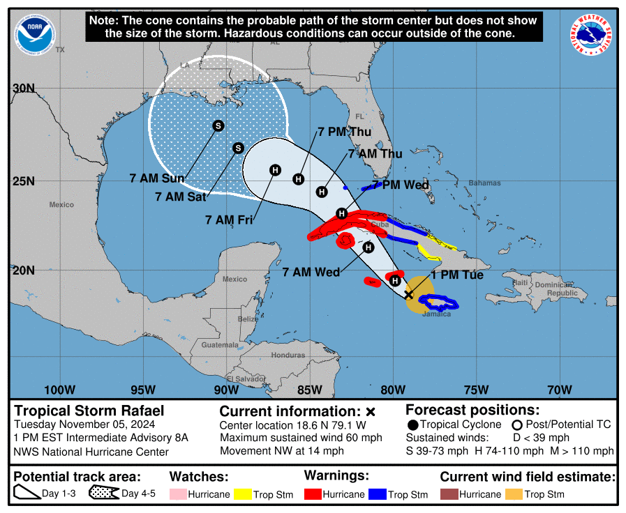
The National Hurricane Center on Sunday continued to forecast a system in the Caribbean would slowly develop into the season’s next tropical depression or storm in the next couple of days, and initial tropical storm watches or warnings could be needed soon. Weather models take it into the Gulf of Mexico next week, and Florida could be a target.
As of the NHC’s 1 p.m. tropical outlook, it was one of two systems under watch while Subtropical Storm Patty continued to spin in the far eastern Atlantic headed for Spain.
For now, the main focus is the broad area of low pressure in the southwestern Caribbean with disorganized showers and thunderstorms.
“Gradual development of this system is expected, and a tropical depression is likely to form within the next couple of days while moving generally northward to northwestward over the central and western Caribbean Sea,” forecasters said.
Heavy rain is forecast whether it develops or not in areas of the western Caribbean including Jamaica, Haiti, the Dominican Republic and Cuba.
“Interests in the western Caribbean Sea should monitor the progress of this system as tropical storm watches or warnings could be required later today or tonight for portions of the area,” forecasters said.
An Air Force Hurricane Hunter aircraft is slated to fly out to the system later Sunday.
The NHC gives is an 90% chance of development in the next two to seven days.
If it grows strong enough, it could become Tropical Storm Rafael.
The long-range forecast models, which will become more clear once the system actually forms, have it heading north into the Gulf of Mexico.
“Global deterministic model runs continue to indicate the feature moving into the Gulf around mid week, but spread and uncertainty remains high,” said Zach Law, a meteorologist with the National Weather Service in Melbourne. “The high spread and uncertainty will likely continue until a well-defined center develops.”
Some models have it moving farther west in the Gulf with Florida’s Panhandle a target, but at least one has it potentially heading for Florida’s Big Bend region again.
The state has already had three landfalls on the Gulf Coast this season with hurricanes Debby, Helene and Milton as well as Hurricane Idalia’s landfall in 2023.
“It still remains too early to determine what, if any, impacts could occur across east central Florida,” Law said. “Residents and visitors should continue to monitor the forecast for updates.”
As for the rest of the tropics, the NHC only gives low chances for a trough of low pressure already near the Greater Antilles to form before it gets sucked into the other growing Caribbean system.
Located a couple hundred miles east of the southeastern Bahamas, it continues to produce disorganized showers and thunderstorms along with gusty winds over the adjacent waters of the southwestern Atlantic.
“Slow development of this system is possible during the day or so while it moves westward toward the southeastern Bahamas and eastern Cuba,” forecasters said. “This system is expected to be absorbed into the low pressure area over the Caribbean Sea by late Monday, ending its chances of development.”
It is still expected to bring heavy rain in the next couple of days to the northern Leeward Islands, Puerto Rico, Hispaniola, eastern Cuba and the southeastern Bahamas.
The NHC gives it a 10% chance of development in the next two to seven days.
Finally, Subtropical Storm Patty, which developed on Saturday, was passing the Azores in the Atlantic heading east.
As of 1 p.m., the center of Patty was located about 225 miles east-southeast of Lajes Air Base in the Azores with maximum sustained winds of 45 mph as it headed east at 16 mph.
A tropical storm warning remained in place for all of the Azores with winds of at least 40 mph extending out for its center up to 80 miles.
“On the forecast track, the center of Patty is expected to move near the southeastern Azores during the next several hours,” forecasters said. “Weakening is expected during the next couple of days, and Patty is forecast to become a post-tropical low later today or tonight.”
Its five-day path has it approaching Spain and Portugal as a post-tropical depression by Tuesday night.
The 2024 Atlantic hurricane season has seen 16 named systems so far with 10 having grown into hurricanes.
The official season runs from June 1-Nov. 30.
https://americanmilitarynews.com/20...system-that-could-threaten-florida-next-week/


