Took my GHB and a tent on a test trip last night. No fire, stealth mission. Have to say, my bag is rock solid !!
You are using an out of date browser. It may not display this or other websites correctly.
You should upgrade or use an alternative browser.
You should upgrade or use an alternative browser.
Quick overnight-er
- Thread starter Colt 1911
- Start date


Help Support Homesteading & Country Living Forum:
This site may earn a commission from merchant affiliate
links, including eBay, Amazon, and others.
Found this Gerber in the tent pocket " bonus"

Score! Nice find!
Where did you go? forest area or desert?Took my GHB and a tent on a test trip last night. No fire, stealth mission. Have to say, my bag is rock solid !!
Where did you go? forest area or desert?

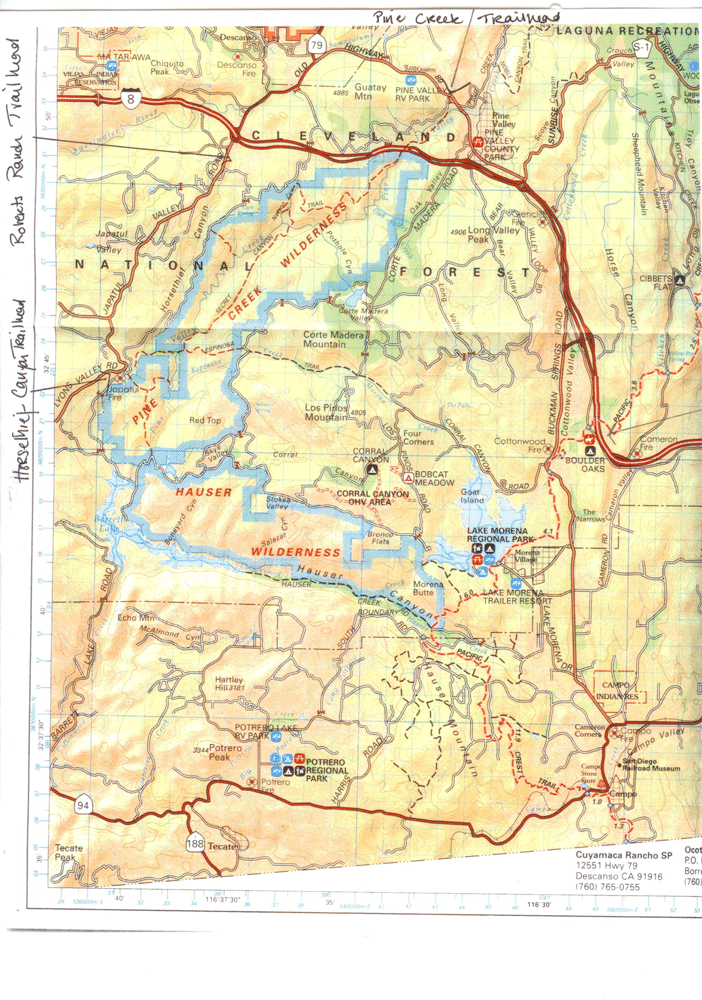
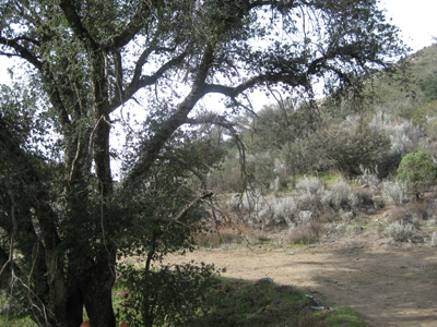
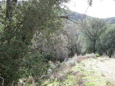
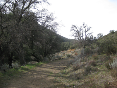
Length of Trail: The easy part of this trail is relatively short, about 3-4 miles. However, it includes magnificent views, varied terrain and a beautiful stream, Pine Valley Creek. It can be extended another 20 miles to include the Secret Canyon Trail, see below.
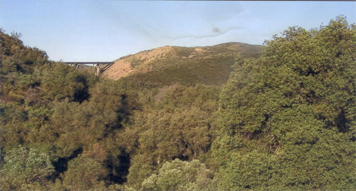
Staging Area: The staging area is at the Pine Creek Trailhead which is located at mile 3.5 on Old Highway 80 just west of Pine Valley. There is a narrow, sometimes single track road down into the valley. There are no specific parking spots for trucks and trailers, but there is plenty of room to park. There are places to tie your horse, restroom facilities and a place to picnic.
Water: There are some seasonal streams on the trail.
Trail Conditions: Easy. There are some hills, closed gates to open. There may be cows grazing in the valley.
Trail Use: You need a National Forest Adventure Pass to use this area. Click here for the US Forest website , or call the Cleveland National Forest Descanso Ranger District (619) 445-6253. The passes can be purchased at stores in Descanso and Pine Valley.
General Trail Info: You can take the fire road up the side of the hill for 1.6 miles until you are stopped by a locked gate. It is still worth doing as the views are amazing and the footing is good with few ruts and rocks. There are two trails to the left where you can leave the fire road and go down into the valley by the Pine Creek. The second trail is wider and less steep than the first one. There are a few cows grazing in the area and be sure to shut all gates.
The alternative route is to take the Secret Canyon trail. This follows the Pine Valley Creek and after two miles you pass under the Pine Valley Bridge of Highway 8. The trail continues for another 11 miles or so and ends in Horsethief Canyon. However, there are steep narrow parts to the trail and I don’t recommend it on horseback. For a more detailed description of the Secret Canyon Trail to Horsethief Canyon, see Jerry Shad’s book, Afoot and Afield in San Diego County.
Photos courtesy of MiriamEaglemon.com

S.D. Horse Trails 2009 All Rights Reserved
Contact Clare Maudsley
Site by RickieDesigns
LinCleveland National Forrest info
Pine Creek Trail
Length of Trail: The easy part of this trail is relatively short, about 3-4 miles. However, it includes magnificent views, varied terrain and a beautiful stream, Pine Valley Creek. It can be extended another 20 miles to include the Secret Canyon Trail, see below.
Staging Area: The staging area is at the Pine Creek Trailhead which is located at mile 3.5 on Old Highway 80 just west of Pine Valley. There is a narrow, sometimes single track road down into the valley. There are no specific parking spots for trucks and trailers, but there is plenty of room to park. There are places to tie your horse, restroom facilities and a place to picnic.
Water: There are some seasonal streams on the trail.
Trail Conditions: Easy. There are some hills, closed gates to open. There may be cows grazing in the valley.
Trail Use: You need a National Forest Adventure Pass to use this area. Click here for the US Forest website , or call the Cleveland National Forest Descanso Ranger District (619) 445-6253. The passes can be purchased at stores in Descanso and Pine Valley.
General Trail Info: You can take the fire road up the side of the hill for 1.6 miles until you are stopped by a locked gate. It is still worth doing as the views are amazing and the footing is good with few ruts and rocks. There are two trails to the left where you can leave the fire road and go down into the valley by the Pine Creek. The second trail is wider and less steep than the first one. There are a few cows grazing in the area and be sure to shut all gates.
The alternative route is to take the Secret Canyon trail. This follows the Pine Valley Creek and after two miles you pass under the Pine Valley Bridge of Highway 8. The trail continues for another 11 miles or so and ends in Horsethief Canyon. However, there are steep narrow parts to the trail and I don’t recommend it on horseback. For a more detailed description of the Secret Canyon Trail to Horsethief Canyon, see Jerry Shad’s book, Afoot and Afield in San Diego County.
Looks like a nice peaceful area!
I may have to check it out this winter.
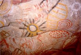
Mt. laguna, Pine Valley is under rated, it was used by the Kumeyaay Indains so you can find broken pottery, grinding holes. During the winter the kumeyaay would head for the desert where i came across this during a back packing trip
 n
n
Not to mention Mt Laguna has 12 miles of down hill single track for mt biking. " KILLER "
Not to mention Mt Laguna has 12 miles of down hill single track for mt biking. " KILLER "
cool! thanks for the info! I will have to check that out as I am a huge fan of the American Indians.Mt. laguna, Pine Valleyis under rated, it was used by the Kumeyaay Indains so you can find broken pottery, grinding holes. During the winter the kumeyaay would head for the desert where i came across this during a back packing trip
Not to mention Mt Laguna has 12 miles of down hill single track for mt biking. " KILLER "
yup, if all us preppers followed the early Native Americans, none would have a problem post-shtf.
lol @ the art on the wall.
anyone else wonder if that was just the kids drawings???
lol @ the art on the wall.
anyone else wonder if that was just the kids drawings???
That's for sure !!yup, if all us preppers followed the early Native Americans, none would have a problem post-shtf.
lol @ the art on the wall.
anyone else wonder if that was just the kids drawings???
Looks like it huh, it's not though.yup, if all us preppers followed the early Native Americans, none would have a problem post-shtf.
lol @ the art on the wall.
anyone else wonder if that was just the kids drawings???
Are there postings near buy to explain what it is, who lived there and when?Looks like it huh, it's not though.
No signs, called Indian hill, It's in Anza Borrego state park
Here is a little info on it, if you need some more or want to check it out let me know i can show you on a topo.
Also Jerry Schad's afoot an afield book has some info on it.
http://www.anzaborrego.net/Travel/AnzaBorrego/post/2009/03/08/Hike-to-Indian-Hill-Pictographs.aspx
Here is a little info on it, if you need some more or want to check it out let me know i can show you on a topo.
Also Jerry Schad's afoot an afield book has some info on it.
http://www.anzaborrego.net/Travel/AnzaBorrego/post/2009/03/08/Hike-to-Indian-Hill-Pictographs.aspx
Thanks for the information!No signs, called Indian hill, It's in Anza Borrego state park
Here is a little info on it, if you need some more or want to check it out let me know i can show you on a topo.
Also Jerry Schad's afoot an afield book has some info on it.
http://www.anzaborrego.net/Travel/AnzaBorrego/post/2009/03/08/Hike-to-Indian-Hill-Pictographs.aspx