Weather in your area?

Homesteading & Country Living Forum

Help Support Homesteading & Country Living Forum:

This site may earn a commission from merchant affiliate links, including eBay, Amazon, and others.
Another 12 hours :

1727149094102.png
 
Moving fast :

1727184787634.png
 
Last edited:
1727216224861.png


Not looking Good in these Old Eyes...!!! 🌪️🌬️💨🌊🌧️⛈️⚡
 
Had some severe weather north of us around 6-7pm. Tornado touched down briefly on the Tn/Va border east of Knoxville. No confirmed casualties at this point.
Expecting 4-7" of rain between tomorrow and Friday evening, mostly from Helene coming up out of the gulf. Her track will vary amounts a lot. We really need the rain, but 7" over 3 days will cause some flooding in low lying areas.
 
Temp in the 90's the last 3 days. Breezy today, made working outside tolerable. Yesterday was brutal...

Started raining lightly about an hour ago. Saw an amazing lighting display, lasted about 20min, continuous thunder.

Just waiting for the hurricane... Hope I don't lose anymore trees, tired of cleaning up the mess.
 
Looking at an evacuation map, I can’t imagine losing all of my possessions because of a hurricane. Where do people go? How do they get out? Florida is unreal. Too many people. @rice paddy daddy hope you are ready.
We just head to a big hotel to the north.
You just secure everything around the house, put the cats in carriers, follow the signs, and listen to the radio.
90
 
1727262075540.png


With a :

1727262122300.png

1727262182022.png
 
Hmmmm... 2 ...?!?

1727262271729.png
 

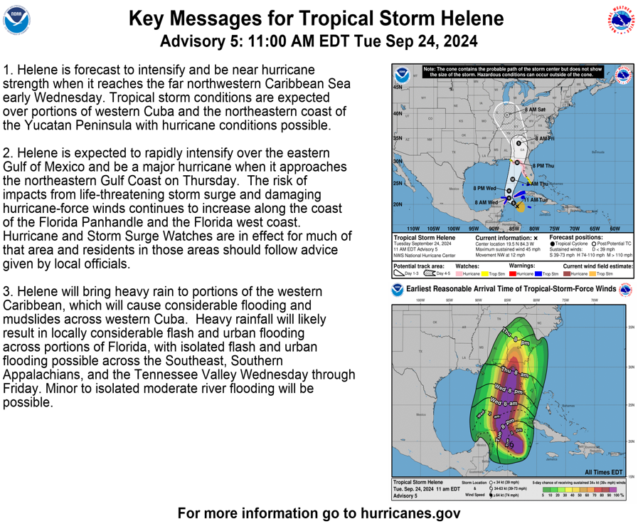
Helene to become major hurricane in Gulf of Mexico, strike US​


People in the Florida Panhandle, Big Bend region and much of the central and eastern Gulf coast need to complete preparations for major hurricane impacts by Wednesday night before hazardous conditions arrive by Thursday.

1727262380711.png


The western Caribbean to the Gulf of Mexico has been an area highlighted by AccuWeather meteorologists as a hot spot for tropical activity since the middle of September.


Gov. Ron DeSantis declared a state of emergency in advance of the strengthening storm. Officials have expanded mandatory evacuation orders for the barrier islands and some low-lying coastal areas from the Florida Big Bend to near Tampa. Hurricane and tropical storm watches and warnings have been issued for much of the Florida Gulf Coast.

https://www.accuweather.com/en/hurr...hurricane-in-gulf-of-mexico-strike-us/1694728
 
AccuWeather began designating the brewing system as a tropical rainstorm this past weekend to raise public awareness and issue its own track map to help people and officials plan ahead.


Helene was a 65-mph tropical storm as of 5 a.m. EDT on Wednesday, a higher wind intensity than the prior advisory.


Justifying the upcoming storm's rapid strengthening​


"The combination of deep warm water (ocean heat content) and low disruptive breezes (wind shear), should assist in rapid strengthening when Helene moves over the Gulf of Mexico from Wednesday to Thursday," AccuWeather Chief On-Air Meteorologist Bernie Rayno said.

1727262519459.png
 
"Most likely, Helene will create its own environment and bring a surge in moisture to the currently dry air over the Gulf," Rayno added. That moistening process was becoming evident in the southeastern Gulf of Mexico on Tuesday.


Helene is forecast to rapidly intensify, with maximum sustained winds increasing by at least 35 mph or more in less than 24 hours.


AccuWeather is expecting Helene to make landfall as a major hurricane of Category 3 strength (sustained winds of 111-129 mph) on the Saffir-Simpson Hurricane Wind Scale. However, it could reach Category 4 status (130-156 mph) at some point while it is over the Gulf of Mexico.


What do AccuWeather meteorologists anticipate?​


At this time, Helene's eye is most likely to track onshore along the Gulf Coast from the western part of the Florida Panhandle to the central part of the Florida Peninsula. This landfall window will continue to narrow once a strong storm center forms and begins to move along.


The highest landfall probability is somewhere along the eastern part of the Florida Panhandle--perhaps in the Big Bend area--late Thursday evening.

https://www.accuweather.com/en/hurr...hurricane-in-gulf-of-mexico-strike-us/1694728
 
we are most likely going to get what's left of the hurricane on Friday, bad timing for us, we have a festival to get ready for Saturday

hope nobody is in the direct path at the coast
 
Back
Top