90's sunny very humid today! Had a half inch of rain yesterday!
You are using an out of date browser. It may not display this or other websites correctly.
You should upgrade or use an alternative browser.
You should upgrade or use an alternative browser.
Weather in your area?
- Thread starter phideaux
- Start date

Help Support Homesteading & Country Living Forum:
This site may earn a commission from merchant affiliate
links, including eBay, Amazon, and others.
Supposed to be nice today, sunny with temps n the 80's. I hope it holds for a while.
Half an hour of sun, heavy rain followed by hours of cloud, then a bit of sun again. Ever bloody day.
The hurricane is already affecting my weather. Tons of moist air being pumped up from the gulf. 70% chance of rain today. Just hit and miss showers, no organized front.
It was 87* at 0630 hours. Suppose to hit 110* today. I gotta get off my butt and go for a walk before my shoes stick to the pavement!

$13.94
$19.95
LifeStraw Personal Water Filter for Hiking, Camping, Travel, and Emergency Preparedness, 1 Pack, Blue
Amazon.com

$22.99 ($7.66 / Count)
LF LIKEFAIR Farmhouse Kitchen Canisters Set of 3,Food Storage Containers for Home Kitchen, Tea, Herbs, Sugar, Salt, Coffee, Flour, Herbs (White & Black)
Likefair-Direct

$14.99 ($5.00 / Count)
$19.99 ($6.66 / Count)
AuldHome Design Farmhouse Galvanized Canisters (Set of 3); Storage Containers for Coffee, Tea and Sugar in Galvanized Iron and Wood Design
ClockworkCornucopia

$29.97
$35.97
GROWIT Heavy Duty Gardening Tools - 22-Piece Gardening Gifts for Women, Mom, Men - Durable, Ergonomic Garden Tool Set
SuperDealsDirect

$31.97 ($10.66 / Count)
$39.90 ($13.30 / Count)
noonberry Kitchen Canisters for Countertop - Set of 3 - Airtight Coffee Tea Sugar Container Set - Country Rustic Farmhouse Canisters Sets for the Kitchen
noonberry

$13.49
$26.99
7 Rules of Self-Reliance: How to Stay Low, Keep Moving, Invest in Yourself, and Own Your Future
Amazon.com

$21.99 ($7.33 / Count)
$27.65 ($9.22 / Count)
Home Acre Designs Food Storage Containers Set with Lids, Farmhouse Home Kitchen Decor Rustic Vintage Canisters
Home Acre Designs
Uh oh, GOLF time!!Supposed to be nice today, sunny with temps n the 80's. I hope it holds for a while.
I can find them but my computer doesn't want to copy and paste anything.
panama jungle time here...i tell ya....folks think they can live without a box fan or ceiling fan or hand fan or a swimming hole to cool off in south is crazy...working in garden picking stuff and more am you drip non stop i tell ya...friday before storm hit i seen lots of folks sitting on creek bank and playing in water with dogs and kids.
Mid 90s, mid 70s humidity
The blue dot is me. Should be fun!! Mid day tomorrow. I am sure we will lose power. Everything is a test. We are ready!


- Joined
- Dec 20, 2017
- Messages
- 16,351
That's tomorrow's forecast? @TexasCharm
Lots of clouds been rolling through here and the humidity is here, sure it will be worse. Fascinates me how storms pull a system towards itself, clouds rolling ahead, clouds rolling to a storm. Awesome as long as it doesn't flood.
Lots of clouds been rolling through here and the humidity is here, sure it will be worse. Fascinates me how storms pull a system towards itself, clouds rolling ahead, clouds rolling to a storm. Awesome as long as it doesn't flood.
- Joined
- Dec 20, 2017
- Messages
- 16,351
Folks in path of the storm keep your head down! Pines start coming down with winds >50mph. Supposed to be winds above 70mph at landfall. I was in sabine pass tx once for a storm with winds that high, only time i was ever in a eye of a hurricane. Nail everything down, better use two nails! 
It's been overcast here all day. Temp never broke 90f, humidity was high though. Been above 80% since yesterday. Same predicted for tomorrow. But on tues/wed i'll be getting the remnants of Beryl.
It's been overcast here all day. Temp never broke 90f, humidity was high though. Been above 80% since yesterday. Same predicted for tomorrow. But on tues/wed i'll be getting the remnants of Beryl.
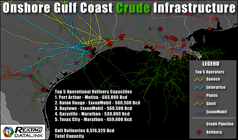
....While nobody is looking:Has anybody thought about all the oil refineries on the Texas coast in the path, that provide most of the country's gasoline?

They will shut them all down before Beryl gets near.
Reuters: "The ports of Corpus Christi, Houston, Galveston, Freeport and Texas City closed on Sunday to prepare for Tropical Storm Beryl which could grow into a Category 2 hurricane after making landfall in the middle of the Texas coast between Galveston and Corpus Christi later on Monday.
Port closures could bring a temporary halt to crude and liquefied natural gas exports, oil shipments to refineries, and motor fuel deliveries from those plants."
Last edited:
weren' t we just talking about the last time those refineries etc got stormed?....While nobody is looking:
Harvey was in 2017.weren' t we just talking about the last time those refineries etc got stormed?
Energy production in the Gulf of Mexico declined in the wake of Harvey by approximately 21% — the output dropped to 378,633 barrels per day from the original 1.75 million barrels of oil produced each day.
Last edited:
- Joined
- Dec 20, 2017
- Messages
- 16,351
these guys are covering it, the link to photo I posted above. The eye is hours away but forecasting possibility of tornado warning for Surfside or Freeport, or a water spout.
- Joined
- Dec 20, 2017
- Messages
- 16,351
Here's Reed Timmer live.
- Joined
- Dec 20, 2017
- Messages
- 16,351
Very exciting, makes me nervous. Do you think you will get hit hard from this, @Supervisor42 ? At this point they think it is edging toward being a category 2. I'm out.
Naa, we'll be fine, @zannej has more to worry about.Very exciting, makes me nervous. Do you think you will get hit hard from this, @Supervisor42 ? At this point they think it is edging toward being a category 2. I'm out.
Texas Charm is in the path of the eye.
"
MATAGORDA, Texas —
Beryl strengthened and again became a hurricane overnight as it made landfall in southern Texas early Monday. The storm's outer bands lashed the coast with rain and intensifying winds as residents prepared for the powerful storm that already cut a deadly path through parts of Mexico and the Caribbean.
The National Hurricane Center issued an updated advisory at 4 a.m. Central Standard Time warning the center of the storm had made landfall near Matagorda, Texas.
“Life-threatening storm surge, heavy rainfall, and strong winds are ongoing across portions of Texas,” the hurricane center said.
The hurricane's top sustained winds were 80 mph as the storm moves north at 12 mph. A hurricane warning is in effect for the Texas coast from Mesquite Bay north to Port Bolivar, the center said.
People on the Texas coast boarded up windows and left beach towns under evacuation order. The storm was projected to come ashore early Monday in the middle of the Texas coast around Matagorda Bay, an area about 100 miles south of Houston, but officials cautioned the path could still change.
As the storm neared the coast, Texas officials warned Sunday it could cause power outages and flooding but also expressed worry that not enough residents and beach vacationers in Beryl’s path had heeded warnings to leave."
https://www.wbaltv.com/article/tracking-beryl-july-8/61529214
We are just starting to get some wind and a steady little rain. Still right in the path of the eye.. should be a strong TS by the time it gets here later this morning. We are 100 miles inland.
I'll stay in touch as long as I can .. I'm sure we'll lose power.
We live on the edge of the Piney Woods.. so pine trees are an issue.
I'll stay in touch as long as I can .. I'm sure we'll lose power.
We live on the edge of the Piney Woods.. so pine trees are an issue.
Just far enough west to get no rain from Beryl, but it's cloudy so it will be cooler!!
- Joined
- Dec 8, 2017
- Messages
- 12,049
Rain last two days.
How can I get rain in S.C., but not Pearl?!??Just far enough west to get no rain from Beryl, but it's cloudy so it will be cooler!!
All I can do is chuckle as the temps climb from the 90's to 100's this week, and I won't be here to "enjoy" the heat. 
I'm west of DFW, hoping for a sprinkle out of Beryl, but doesn't look good! It is a beautiful morning, a cloudy day would be nice! After today the temps go up and all rain chances are gone for a while!!Rain last two days.
How can I get rain in S.C., but not Pearl?!??


